
I suppose it isn’t ironic to anyone that Iceland is home to some hot attractions, such as volcanoes. On August 28, 2014, their Bardarbunga (sounds like something out of Ninja Turtles) volcano erupted a bit. All sorts of tools have been used to observe the angry mountain: webcams, helicopters, cars, and planes. Of course, most of these require a person to be there, operating the transportation vehicles for the photographers on board. Even the webcam probably required a brave soul to get as close as possible to the volcano placing the webcamera right on the brink of bowel evacuation and certain death.
But, there is a safer and saner way to take pictures of a volcano: satellites. Satellites are great for this sort of work, taking photos of volcanoes at decent resolutions, allowing you and I to look at those images from the comfort of our sofas and chairs. No worries about bowel evacuation (unless you have a severe case of food-poisoning–then why are you even up?). Certain death isn’t even on the horizon.
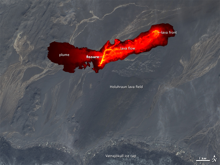
The satellites used to image the Bardarbunga volcano were, according to this Livescience.com post, both from the National Aeronautic and Space Administration (NASA). The second satellite to get an image of the active volcano (the first image in this post) was the Earth Observing-1 satellite in a sun-synchronous low earth orbit. It used the Advanced Land Imager payload to take the volcano’s image. The resolution of that image isn’t that great–every pixel in the image represents 98 feet if taken in color. In black and white the resolution gets better, with each pixel in the image representing 33 feet. The latest DIgitalglobe WorldView-3 satellite imager will take pictures in which one pixel represents less than 12 inches.

The first NASA satellite to get a look at and send data back about the volcano was the Aqua satellite, using the Moderate Resolution Imaging Spectroradiometer (MODIS) payload. Aqua is in a near-polar LEO. The MODIS payload was used to create a false-color image by combining infrared and visible light bands to highlight certain features in the picture. You can go to this site to see the differences between some of MODIS’ images using this method.
Either satellite is definitely preferable to flying, driving, and hiking anywhere near an active volcano. And the pictures each satellite has produced give information that those closer to the ground might miss. Safety first, folks. Safety first.
